🛰️ Apiary satellite view
See also Pollination optimization with hive placement recommendation
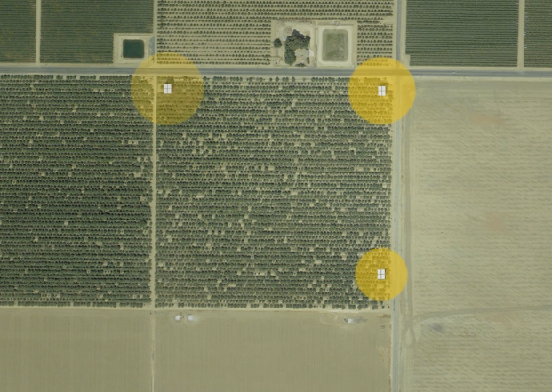 beehero.io hive placement optimization
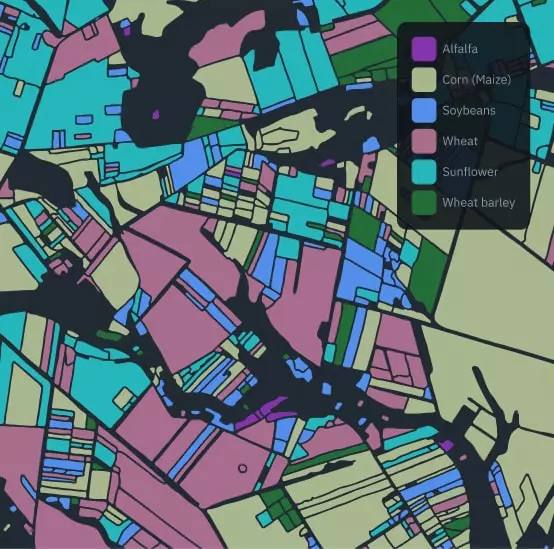 eosdata field classification
References and potential data sources
-
EOS Data - crop types https://eos.com/products/crop-monitoring/custom-solutions/crops-classification/
-
Sentinel-2 https://apps.sentinel-hub.com/eo-browser/?zoom=15&lat=59.45154&lng=24.89232&themeId=DEFAULT-THEME&visualizationUrl=https%3A%2F%2Fservices.sentinel-hub.com%2Fogc%2Fwms%2Fbd86bcc0-f318-402b-a145-015f85b9427e&datasetId=S2L2A&fromTime=2023-09-14T00%3A00%3A00.000Z&toTime=2023-09-14T23%3A59%3A59.999Z&layerId=2_FALSE_COLOR&demSource3D="MAPZEN"
-
https://dataspace.copernicus.eu/browser/?zoom=13&lat=59.43336&lng=24.9207&themeId=DEFAULT-THEME&visualizationUrl=https%3A%2F%2Fsh.dataspace.copernicus.eu%2Fogc%2Fwms%2Fa91f72b5-f393-4320-bc0f-990129bd9e63&datasetId=S2_L2A_CDAS&fromTime=2023-08-15T00%3A00%3A00.000Z&toTime=2023-08-15T23%3A59%3A59.999Z&layerId=SCENE-CLASSIFICATION&demSource3D="MAPZEN"&cloudCoverage=7
-
show pollen API 1kmx1km with google https://mapsplatform.google.com/maps-products/pollen/ https://console.cloud.google.com/google/maps-apis/api-list?project=gratheon
-
https://apps.sentinel-hub.com/sentinel-playground/?source=S2L2A&lat=40.400032551179976&lng=-3.7298583984375&zoom=12&preset=null&layers=B01,B02,B03&maxcc=20&gain=1.0&gamma=1.0&time=2023-05-01|2023-11-02&atmFilter=&showDates=false
-
https://apps.sentinel-hub.com/eo-browser/?zoom=15&lat=59.45154&lng=24.89236&themeId=DEFAULT-THEME&visualizationUrl=https%3A%2F%2Fservices.sentinel-hub.com%2Fogc%2Fwms%2Fbd86bcc0-f318-402b-a145-015f85b9427e&datasetId=S2L2A&fromTime=2023-09-14T00%3A00%3A00.000Z&toTime=2023-09-14T23%3A59%3A59.999Z&layerId=2_TONEMAPPED_NATURAL_COLOR&demSource3D="MAPZEN"
Potential approach
- https://medium.com/@ya_71389/sentinel-2-deep-resolution-3-0-c71a601a2253
- https://medium.com/sentinel-hub/multi-temporal-super-resolution-on-sentinel-2-imagery-6089c2b39ebc
- [https://medium.com/sentinel-hub/how-to-normalize-satellite-images-for-deep-learning-d5b668c885afh](https://medium.com/sentinel-hub/how-to-normalize-satellite-images-for-deep-learning-d5b668c885af%5Bh%5D(https://github.com/sentinel-hub/eo-learn))
- https://github.com/sentinel-hub/eo-learn
Estonia only
-
pollution data in estonia, city specific http://airviro.klab.ee/en https://hub.eaaci.org/patients_resources/worldwide-pollen-map/
Glossary
- NDVI (Normalized Difference Vegetation Index): NDVI is a commonly used vegetation index calculated from satellite imagery. It quantifies the amount of live vegetation in an area. NDVI values typically range from -1 to 1, with higher values indicating healthier and more abundant vegetation.
- True Color - Visual interpretation of land cover.
- False Color - Visual interpretation of vegetation.
- NDVI - Vegetation index.
- Moisture index - Moisture index
- SWIR - Shortwave-infrared index.
- NDWI - Normalized Difference Water Index.
- NDSI - Normalized Difference Snow Index.
https://hub.docker.com/r/kartoza/geoserver